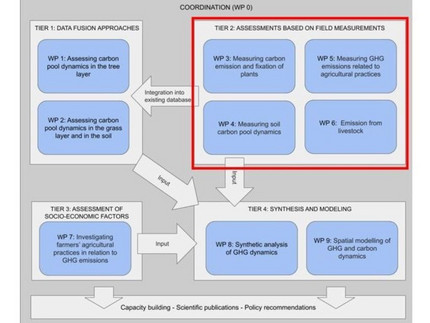
Assessment Based on Field Measurements
In Tier 2 (WPs 3-6), the emission and fixation of various greenhouse gases (including CO2) will be directly measured in the three West African countries Niger, Burkina Faso and Ghana along a transect that covers the entire climatic conditions in West Africa from the arid Sahel to the tropical Guinean climate zone. Along the transect, six study sites - two in each country - will be located with a minimum distance of 200 km to each other. The sites will be Tillabéri [Niger] - Desert; Maradi [Niger] and Kaya (Burkina Faso] - Sahel; Pô [Burkina Faso] - SudanoSahel; Tamalé [Ghana] - Sudanian zone; Koumassi [Ghana] - Guinean zone. In each of the six study sites, data will be collected in three land-use systems (croplands, land recently converted to cropland, and near-natural vegetation). Hence, we will consider two cropland categories, following IPCC guidelines (Sass & Yang, 2006): Cropland Remaining Cropland (CC) and Land Converted to Cropland (LC). Land-use conversions to cropland (LC) from forest, savannah, grassland and wetlands usually result in a net loss of carbon from biomass and soils as well as N2O to the atmosphere. This category comprises newly established croplands (i.e. land with a cultivation time of less than 20 years). In contrast, CC are croplands intensively cultivated for over 20 consecutive years. Within croplands, carbon losses are also taking place, e.g. when traditional parkland systems with a high tree cover are converted into fields nearly bare of trees, as often done in cotton farming. The near-natural vegetation consists of protected areas that can be used as a benchmark to do comparisons with CC and LC.

