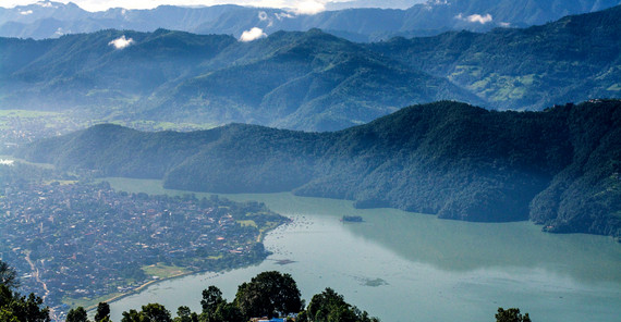
The Himalayas are the tallest mountain range on Earth – and one of the most active, growing by about a centimeter a year, which regularly shakes the earth. Landslides and debris flows bringing boulders, mud, and water barreling downhill are no rare occurrence. Sometimes the earth movements push up walls of soil, behind which water accumulates, forming both large and small lakes. While this does create unique impressions of nature, it does also present new potential hazards. In the mountainous country of Nepal, Oliver Korup and his team from the Institute of Earth and Environmental Sciences analyze silent witnesses to disastrous lake outbursts that have been shaping the region for thousands of years.
The view makes the hearts of geologists and laypeople alike race: snow-capped mountain ridges as far as the eye can see, masses of ice heaping up into giant glaciers, and crystal blue lakes in between. In such panoramas, geoscientist Oliver Korup searches for hidden indications of natural hazards. “Glacial lake outbursts in the Himalayas are one of the most interesting natural risks for researchers,” he explains. Lakes are often formed by glacial water piling up behind boulders and masses of soil. Due to global warming, more snowmelt could reach existing lakes, form new ones, and even cause more lake outbursts, researchers around the world suspect.
At some point, these natural “bathtubs” spill over, and masses of water make their way downhill. If this happens very suddenly – for instance in the wake of an earthquake, a rockslide, or heavy rainfall – the consequences may be devastating. The water sweeps up soil, sediment, and rocks, accumulating immense power along the way. The avalanche then pours over houses, settlements, and hydroelectric power plants like “liquid concrete” and even shifts the course of entire rivers. The insidious thing is that lake outbursts also occur under sunny, blue skies, often without warning. Dozens of these events have been documented over the past 100 years, Oliver Korup explains. Yet how often major ones occur is unclear. “The number of unreported events is thought to be high.”
To shed some light on the situation, researchers are reconstructing previous outbursts. To do this, they search onsite for sediments left behind by the outbursts. Their analyses will help to clarify when outbursts occurred, what caused them, and on what scale.
Around Pokhara, Nepal’s second-largest city, the researchers made a find. “Pokhara was built on what is, even for the Himalayas, an unusually large talus fan,” Korup explains. And what makes it so interesting for geoscientists is that the substrate consists of sediments. Most remarkable, though, are two features: “The fan is very young and was formed – on a geological timescale – within mere moments.”
The researchers from Potsdam were the first to prove and corroborate these indications through independent methods: systematically mapping the territory, measuring rocks and classifying their origin by mineral composition, aging sediments, and analyzing surface structures and the thickness of sediments using laser scanning. Oliver Korup describes their findings as “alarming”, as the age dating revealed that the organic material originates mainly from the early Middle Ages and is around 700 years old. “The ground of Pokhara is very, very young,” Oliver Korup underlines. The sediments also do not originate from the hills around the city but rather from a region some 30 to 70 kilometers away, up in the high Himalayas. One or more gigantic lake outbursts may have brought the material here, the researchers suspect.
It seems unlikely that this is an isolated case. Data indicate that three major floods washed up massive amounts of sediments here over 500 years. “Whether this could happen again is hard to tell, but it can’t be ruled out. We don’t yet know of any events that have so radically changed the landscape yet been so geologically young.”
This research is linked to the research initiative NEXUS: Earth Surface Dynamics, which clusters approaches from various scientific disciplines in the Berlin-Brandenburg area within the overarching theme of Earth surface dynamics. The University of Potsdam, along with its partnering institutions the Helmholtz-Centre Potsdam - German Research Centre for Geosciences (GFZ), the Alfred Wegener Institute Helmholtz Centre for Polar and Marine Research (AWI) and partners from the Potsdam Institute for Climate Impact Research (PIK), the Museum für Naturkunde - Leibniz Institute for Evolution and Biodiversity Science (MfN) and the Technische Universität Berlin (TUB) therefore combines the outstanding expertise from geo-, bio-, climate and data sciences.
Text: Heike Kampe
Translation: Monika Wilke
Online published by: Daniela Großmann
Contact us: onlineredaktionuuni-potsdampde

