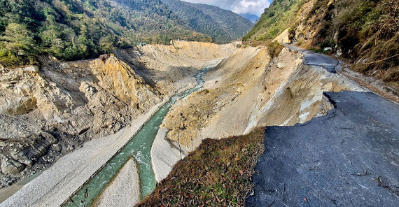
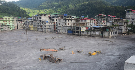
The catastrophe was triggered by a Glacial Lake Outburst Flood (GLOF) – one of the most dangerous natural hazards in the Himalayas. The flood occurred at South Lhonak Lake, a glacial lake at an altitude of 5200 meters. On October 3, 2023 at 22:12 (local time), part of the frozen glacial moraine on the northern shore of the lake broke away. The large mass of debris, sand and ice collapsed into the lake, triggering a tsunami around 20 meters high. This wave destroyed the natural dam of debris retaining the lake and released around 50 million cubic meters of water – a volume equivalent to 20,000 Olympic swimming pools. The sad balance of the flood: almost 130 fatalities or missing persons, almost 26,000 buildings, 31 central bridges and 18.5 kilometers of roads as well as five hydroelectric power plants were destroyed.
The massive flood swept away huge amounts of rock and earth. In many places, adjacent slopes started to slide, causing a total of 270 million cubic meters of debris to enter the floodwater. This material played a key role in the flood damage, as many of the villages affected downstream were buried under meters of sand and gravel. The series of events can be linked to the retreat of the South Lhonak Glacier and the warming of the permafrost in response to rising temperatures in the region.
Thanks to the Centre national d'études spatiales (CNES), the team received high-resolution remote sensing data very quickly after the flood. With the help of satellite images, which show the earth's surface from two different angles, they created detailed 3D models of the terrain before and after the flood. The resulting change maps give the researchers very precise insights into the spatial patterns of erosion and deposition.
The changes to the river also increase the risk of future floods and landslides. There are thousands of glacial lakes in the Himalayas and GLOF flooding is a growing risk as glaciers continue to retreat and permafrost thaws. In addition, almost half of the damaged buildings were only built in the last ten years, which illustrates how growing settlements in flood areas contribute to disasters. First author Ashim Sattar from the Indian Institute of Technology Bhubaneswar says: “As we work to reduce the risk of GLOFs in the Himalayas, it is clear that we need a multi-faceted approach to managing these events. This includes early warning systems, better regulatory frameworks, a paradigm shift in GLOF monitoring and modeling techniques, as well as community preparedness and education programs along the rivers at risk.”
Special attention is also paid to the construction and operation of hydropower plants. Wolfgang Schwanghart, co-author of the study and scientist at the Institute of Environmental Sciences and Geography at the University of Potsdam, is dedicated to their analysis: “Hydropower is essential for the energy revolution in countries like India,” he says. “One power plant was completely destroyed and several were damaged. The eruption of South Lhonak Lake shows that building power plants in the steep valleys of the Himalayas is very risky, especially in times of climate change.”
Link to Publication: A. Sattar et al., The Sikkim flood of October 2023: Drivers, causes and impacts of a multihazard cascade, Science 10.1126/science.ads2659 (2025).
Image 1: A path of devastation along the Teesta River. The flood undercut the slopes in many places, triggering landslides. Credit: Praful Rao.
Image 2: Buildings and cars in the town of Rangpo were buried under the sediment masses of the flood. Credit: Praful Rao.
Contact:
Dr. Wolfgang Schwanghart, Institut für Umweltwissenschaften und Geographie
Tel.: +49 331 977-203175
E-Mail: wolfgang.schwanghartuuni-potsdampde
Media Information 31-01-2025 / Nr. 011


