NamTip Phase 1
Objectives of NamTip Phase 1
The central objectives of NamTip Phase 1 were to understand both ecological and social drivers for desertification tipping points (DTPs), including their social-ecological effects (objective I) and to research and communicate management interventions (objective II). Drylands are known for so-called tipping point phenomena, where changing environmental conditions, e.g. droughts, in combination with increasing land use pressure can cause ecosystems to suddenly “tip over”. This can have serious ecological and socio-economic consequences. An important type of land degradation in drylands is known as desertification. Accordingly, the NamTip project focused on desertification tipping points (DTPs) during its first phase. Namibia's Waterberg region was chosen as the study area because a variety of landuse types are found within close proximity (communal and freehold grazing lands, communal conservation areas as well as a national park). Furthermore, the region is characterized by steep degradation gradients.
Structure of NamTip Phase 1
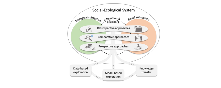
Understanding and solving complex and urgent environmental problems requires a highly integrated, interdisciplinary approach. NamTip followed this approach and integrated natural and social sciences in an overarching research design:
The collection of empirical data was divided into three modules, which aimed to understand DTP behavior using three complementary methods, namely retrospective, comparative and prospective approaches. Each module consisted of two work packages (WPs) that collected specific data on the ecological subsystem (work package “E”) and on the social subsystem (work package “S”). The work in these three modules led to the achievement of the project objective I.
The first module comprised the retrospective analysis of tipping points from time series (WP E1) in combination with archive research and interviews with experienced farmers and experts (WP S1). By integrating the results of both work packages, we were able to understand human and environmental factors contributing to DTPs, and consequently to identify early warning indicators and socio-economic impacts of DTPs on land management systems from a historical perspective.
The second module used a comparative approach along spatial gradients of land use pressures. Hence, a so-called space-for-time substitution was used to compare non-desertified ecosystems (WP E2) with desertified ones, and to characterize farms and community villages with different degrees of degradation and livestock densities (WP S2). Ecological and anthropological fieldwork took place at the same locations, allowing for a deep understanding of social-ecological interactions and feedback.
The third module followed a prospective (i.e. experimental) approach to investigate socio-ecological aspects that were not accessible from observational studies. These included the field experiment TipEx (WP E3) and the implementation of the scientific game “NamSed” (WP S3).
Results of these work packages were incorporated into three overarching, interdisciplinary work packages, which were intended to achieve the project objective II. By integrating empirical results of the previous WPs into WP 4, a data-based investigation of early warning indicators and management options was conducted first. WP 5 combined the knowledge gained from all previous WPs to investigate the coupled social-ecological systems in an agent-based simulation model. Finally, WP 6 promoted academic and non-academic capacity building and disseminated the new knowledge on DTPs through transdisciplinary collaboration. Finally, WP 0 ensured the project coordination, as well as internal and external communication.
Main results of NamTip Phase 1
A summary of the main results of NamTip Phase 1 can be found here:
- Final Report of NamTip Phase 1 (PDF, 2 MB)

