NamTip Phase 2
Objectives and Approaches of NamTip Phase 2
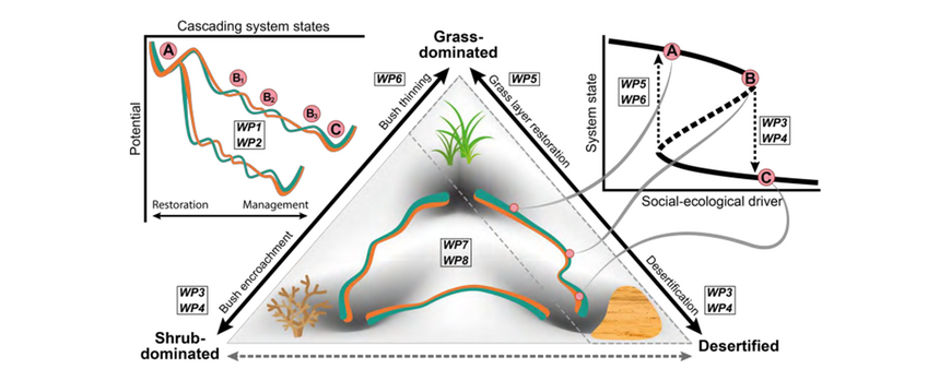
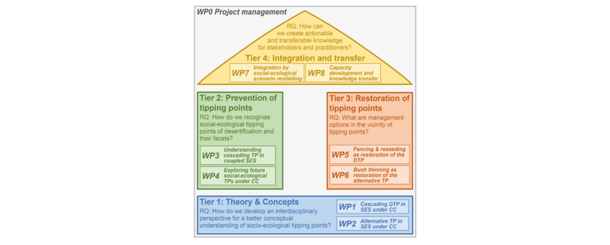
In the second phase of the NamTip project, scientists and stakeholders collaborate closely to gain a better knowledge on the development of socio-ecological tipping points (TPs), including their ecological and social drivers, and to explore management options for preventing TPs or restoring ecosystems that have passed a desertification tipping point (DTP) or the alternative TP of woody plant encroachment. Special emphasis is laid on understanding the role of climate change (CC) for TP behavior. Finally, gained knowledge is integrated using modelling for scenario development, as well as stakeholder-specific capacity development and knowledge transfer.
The Greater Waterberg Landscape of Namibia serves as an example region, representative for many dryland areas in the world, for which conceptual and methodological approaches and their subsequent implementation are specified. The interdisciplinary cooperation between social and natural sciences is made possible by a joint research design, structured into eight work packages (WPs) addressing four overarching research questions (RQ, corresponding to the four project tiers). At the same time, a transdisciplinary approach is pursued in order to ensure early integration of the stakeholders and to ensure that the project is geared to the problems and needs on site.
During Phase 2, the NamTip consortium will study the threefold link between grass-dominated, shrub-dominated and desertified system states in a highly integrated manner that links the four research questions (tiers) specified above. The team will continue to concentrate its empirical work on the Greater Waterberg Landscape in Namibia. Namibia is the driest country in sub-Saharan Africa, representative for many dryland areas in the world that are already characterized by scarce natural resources, and now face both the problem of a fast population growth, and severe climate change impacts such as an increasing frequency and intensity of droughts. These factors make Namibia a well-suited study area for understanding DTPs, and for identifying appropriate management and policy measures to prevent and revert them. The Greater Waterberg Landscape features areas with different land tenure (communal and freehold farmland) in close vicinity of each other, which makes it ideal for NamTip’s comparative approach. Regarding the factors of desertification (climate change impacts combined with population density and overgrazing effects), the study area is not only representative for larger parts of Namibia, but also other global dryland systems and the problems they are facing.

An overview of the objectives, structure, and main results of the previous project phase can be found here: NamTip Phase 1

