Earthquake near Herzberg / Doberlug-Kirchhain (southern Brandenburg), shows the need to densify the Brandenburg earthquake monitoring network
On October 18, 2024 at 12:50 (10:50:52 UT), a magnitude 3.1 earthquake shook the area around Herzberg and Doberlug-Kirchhain. The earthquake was felt over a wide area, although it occurred at midday. This was a rare event. The Herzberg town chronicle reports an earthquake in 1483, which caused the church tower to collapse and the town to burn down. However, the actual existence of this historic earthquake with an estimated (macroseismic) magnitude of 2.9 is still disputed today (Grünthal, 2006, Leydecker, 2011). A microquake with a magnitude of 0.7 (not noticeable) already occurred in the hearth area on 17.9.2024. A non-perceptible earthquake with the same magnitude was also registered in 1984 in the station network of the ZIPE (Central Institute for Physics of the Earth) at that time (Grünthal, 2006).
The station closest to the current earthquake source at a distance of around 50 km is operated by the Institute of Geosciences at the University of Potsdam in cooperation with the Federal Institute for Materials Research (BAM) at its Technical Safety Test Site (TTS) in Horstwalde in a 40 m deep borehole.
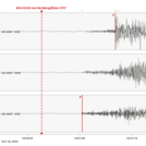
Figure 1 shows the recording of this seismometer in all three spatial directions. The first noticeable strong impulse is formed by the rapidly propagating compression wave, which can be seen particularly well on the vertical component. It is followed after 8 s by the shear wave, which has comparatively much higher amplitudes on the horizontal components. The maximum amplitude reached 60 micrometers/s vibration velocity in Horstwalde.
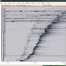
Figure 2 shows a montage of all recordings from seismic stations in Germany that were used by the Federal Earthquake Service at the BGR (Federal Institute for Geosciences and Natural Resources) for localization.
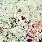
Figure 3 shows the directions to the relevant stations in map view. The low density in the northern direction is striking, as there are only three seismic stations in Berlin and Brandenburg.
Unfortunately, only a very approximate focal depth can be given for the earthquake on October 18, as recordings in the vicinity of the focal point are required for a good focal depth determination. However, a precise determination of the depth is of great importance for assessing the risk of damage. This also applies to answering the question of whether the event can be assigned to a known tectonic fault, which would therefore have to be classified as active.
The Herzberg / Doberlug-Kirchhain earthquake demonstrates the need to consolidate the German seismological station network in order to enable reliable depth estimates of seismic events in Brandenburg. The establishment of an independent seismological station network in Brandenburg should be promoted in the interest of the population of Brandenburg.
Grünthal, G. (2006): Die Erdbeben im Land Brandenburg und im östlichen Teil Deutschlands. Brandenburgische Geowissenschaftliche Beiträge, 13, 1/2, 165-168.
Leydecker, G. (2011): Erdbebenkatalog für Deutschland mit Randgebieten für die Jahre 800 bis 2008, Schweizerbart Science Publishers, Stuttgart, ISBN-Nr. 9783510959891, Geologisches Jahrbuch Reihe E, Band E 59.
Contact: Prof. Dr. Frank Krüger, UP


